
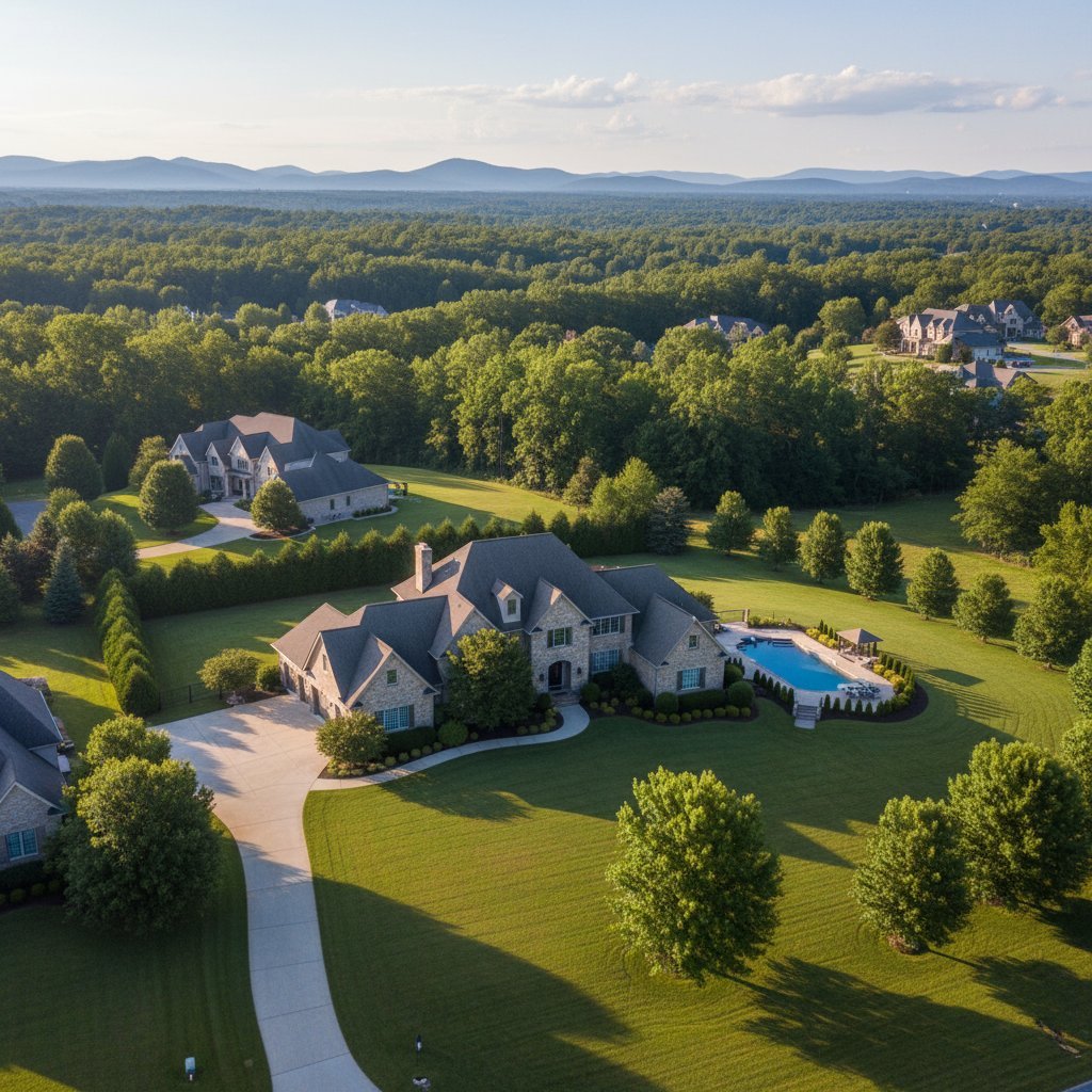
Real estate listings compete for attention across property search websites, social media, email campaigns, and brokerage marketing channels. Strong ground-level photography remains essential, but certain properties benefit from an additional perspective that traditional photography cannot easily provide.
Drone photography allows real estate professionals to show a property from above, revealing its layout, lot, exterior features, surrounding landscape, and relationship to nearby amenities. When used strategically alongside professional interior and exterior photography, aerial images can give buyers a clearer understanding of the property before they schedule a showing.
Key Takeaways
Drone photography can show a property's layout, lot, exterior features, and surroundings from perspectives unavailable at ground level.
Aerial images are especially useful for large lots, luxury homes, acreage, commercial properties, land, and homes near notable amenities.
Drone photography should complement rather than replace professional interior and exterior images.
The most effective aerial photographs highlight information that matters to buyers instead of simply adding dramatic images.
Weather, sunlight, landscaping, surrounding properties, and airspace restrictions can affect a drone photography session.
Commercial drone photography in the United States should be performed in compliance with applicable FAA requirements.
What Is Real Estate Drone Photography?
Real estate drone photography uses an unmanned aircraft equipped with a camera to capture still photographs and, when appropriate, video from elevated positions.
Unlike traditional exterior photography, which is normally taken from street or ground level, a drone can photograph the home from above and from angles that reveal more of the site.
This perspective can help buyers understand features that may otherwise be difficult to communicate through photographs alone.
Aerial photography may show the relationship between the house and backyard, the shape of the lot, outdoor living areas, driveways, detached structures, surrounding streets, and nearby landscape.
For some properties, those details can be as important as what buyers see inside the home.
What Can Drone Photography Show That Ground Photography Cannot?
Ground photography remains the foundation of most real estate listings, particularly for interiors.
Drone photography solves a different problem.
| Property Detail | Ground Photography | Drone Photography |
|---|---|---|
| Interior rooms | Excellent | Not applicable |
| Front elevation | Excellent | Adds elevated context |
| Backyard | Good | Shows overall layout |
| Large lot | Limited perspective | Shows scale and configuration |
| Roof and exterior layout | Limited | Easier to visualize |
| Nearby landscape | Partial | Broader context |
| Detached buildings | Individual views | Shows relationship to main home |
| Community surroundings | Limited | Can provide broader perspective |
Aerial images become most valuable when they provide useful property information rather than simply looking impressive.
Showcase the Entire Property Layout
One of the strongest uses of drone photography is showing how different parts of a property connect.
Consider a home with a swimming pool, detached garage, guest house, large backyard, garden, and extended driveway.
Traditional photographs can document each individual feature, but buyers may still struggle to understand where everything is located.
An aerial photograph can show those features together in a single frame.
This makes drone photography especially useful for properties where the lot itself is an important selling feature.
Real estate professionals can learn more about this approach through The Impact of Drone Photography on Real Estate Marketing.
Highlight Outdoor Features More Effectively
Outdoor amenities can be difficult to photograph from ground level when the objective is to show their scale.
Pools, patios, decks, landscaping, sports courts, gardens, long driveways, and large yards can often benefit from elevated photography.
Aerial images can provide enough height to show the relationship between these features and the home.
The photographer does not always need to fly extremely high.
Moderately elevated angles can sometimes be more useful because they preserve architectural detail while revealing enough of the property to provide additional context.
The objective should be clarity, not simply altitude.
Show the Surrounding Area
Location is one of the most important considerations in real estate, but traditional listing photography typically stops at the property boundary.
Drone photography can sometimes provide broader visual context.
Depending on the property and location, aerial images may help illustrate proximity to open space, trails, golf courses, bodies of water, neighborhood features, or distinctive scenery.
These photographs should remain accurate.
An image should not create the impression that an amenity is immediately adjacent to the property when it is actually much farther away.
Drone photography works best when it helps buyers understand location rather than exaggerating it.
Which Properties Benefit Most from Drone Photography?
Not every listing needs aerial photography.
For a small condominium unit where the building exterior and surrounding area are already adequately documented, drone images may add relatively little.
Other properties can benefit significantly.
Property Type
Why Drone Photography Can Help
Luxury home
Provides dramatic exterior presentation
Large residential lot
Shows property scale
Acreage
Helps communicate land and surroundings
Waterfront property
Shows relationship to the water
Mountain or scenic property
Captures landscape context
Farm or ranch
Shows acreage and improvements
Commercial property
Shows building, parking, and access
Vacant land
Helps viewers understand terrain and shape
Multi-building property
Shows how structures relate
The decision should be based on whether the aerial perspective communicates something meaningful about the listing.
Create Stronger Hero Images for Listings
The first photograph in an online property listing carries significant responsibility.
It needs to make the property recognizable and encourage the viewer to continue exploring the listing.
For certain homes, an elevated exterior photograph can work well as a hero image.
A slightly raised angle may show the front elevation, landscaping, driveway, roofline, and surrounding environment more effectively than a photograph taken directly from the sidewalk.
However, an aerial photograph should not automatically become the first image simply because a drone was used.
The strongest photograph should lead the listing.
For some properties, that may still be a traditional exterior image or a particularly attractive interior space.
Combine Drone Photography with Professional Ground Images
Drone photography is most effective as part of a complete real estate photography package.
Buyers still need clear images of kitchens, bedrooms, living areas, bathrooms, architectural details, and other interior spaces.
Aerial photographs provide context.
Traditional photographs provide detail.
Used together, the two perspectives can tell a more complete visual story.
Consistency also matters.
Color, brightness, exposure, editing, and image quality should feel coordinated across both aerial and ground photography so the listing presents a unified visual style.
Professional photographers also need equipment suited to the assignment. Optimizing Camera Equipment for Real Estate Photography provides additional insight into the tools used to create professional property images.
Commercial Drone Photography Requires Proper Compliance
Drone photography for real estate marketing is a commercial use of drone technology.
In the United States, drone operations conducted for work or business generally fall under FAA rules for commercial drone operations. FAA guidance states that operators flying under Part 107 must meet applicable certification and operating requirements.
Controlled airspace can introduce additional authorization requirements, which can affect whether and when a particular property can be photographed.
For agents and property owners, working with a knowledgeable professional helps ensure that the photography plan accounts for both creative goals and operational requirements.
Frequently Asked Questions
Is drone photography worth it for every real estate listing?
Not necessarily.
Drone photography offers the greatest value when the property has features that are difficult to communicate from ground level, such as acreage, extensive landscaping, outdoor amenities, multiple structures, commercial parking areas, or distinctive surroundings.
Can drone photography show property boundaries?
Drone photographs can help viewers understand the general shape and layout of a property, but a photograph itself should not be treated as a professional land survey.
If property lines are added as graphics, they should be based on reliable information and presented carefully to avoid misleading buyers.
Does drone photography increase a property's value?
Drone photography does not change the underlying market value of a property.
Its role is marketing. Strong aerial photographs can help communicate the property's features and surroundings more clearly, potentially making the listing more visually compelling to prospective buyers.
Should drone photography replace traditional real estate photography?
No.
Interior and ground-level exterior photographs remain essential for showing rooms, finishes, architecture, and property details. Drone photography works best as a complementary tool that adds site and location context.
Build a More Complete Visual Story of the Property
Drone photography gives real estate professionals a perspective that traditional photography cannot fully reproduce.
It can show how a home sits on its lot, reveal outdoor amenities, communicate the scale of larger properties, and place a listing within its surrounding environment.
The strongest results come from using aerial photography selectively.
Rather than adding drone images simply because they look dramatic, choose views that answer questions buyers may have about the property.
Combine those aerial photographs with strong interior and exterior images, accurate presentation, thoughtful editing, and a deliberate listing sequence.
For properties that benefit from an elevated perspective, professional drone photography can become a valuable part of a more complete real estate marketing package.
Explore Drone Services to learn more about using aerial imagery to showcase real estate listings.